
Iceland is renowned for its stunning and dynamic landscapes, with lush mountains, ancient glaciers, and over 10,000 waterfalls sprinkled across the country. With so many incredible cascades, it can be hard to know which ones to prioritize visiting if you only have a short period of time in Iceland.
My husband, Justin, and I have spent over a month in Iceland, exploring as many of the beautiful cascades that we can squeeze in, from ones that are located just a short drive from the capital city of Reykjavik to more remote ones, tucked away in the beautiful eastern fjords. Here are 12 of the most beautiful waterfalls in Iceland to add to your itinerary in the Land of Fire and Ice.

This post may contain affiliate links. If you make a purchase through them, we may receive a small commission, for which we are extremely grateful, at no extra cost to you.
Waterfalls in Iceland
Many travelers only have a short period of time to explore Iceland and stick close to the capital city of Reykjavik and along the southwestern coastline of the country, which is packed with popular sites, like Vik and Jökulsárlón. Accordingly, I’ve organized the waterfalls below, based on their proximity to Reykjavik, working counter-clockwise along the Ring Road.
1. Glymur
- How tall is it? 198 meters (650 feet)
- Where is it located? Glymur is located here, nestled in the Hvalfjörður fjord about an hour and 10 minutes northeast of Reykjavik.
- How much does it cost? Parking and admission to the waterfall is free!
- How can you get there? You can either drive yourself in a rental car or take a tour, like this private hiking option.
Glymur is a stunning waterfall, dramatically cascading over a cliffside into a lush canyon to the Botnsá River below.
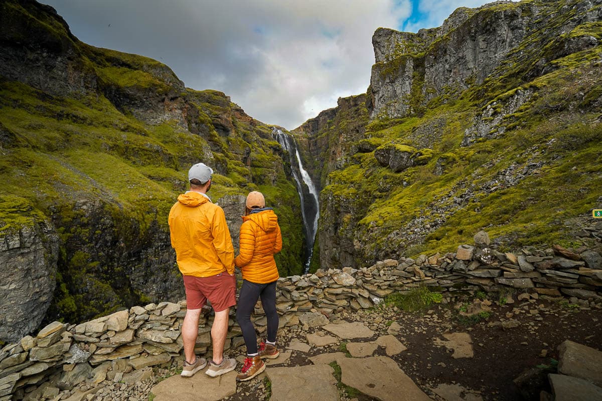
Glymur is unique in a few ways—it’s one of the only waterfalls in Iceland to not include “foss” (i.e., “falls”) in its name and has a seriously impressive height. At 198 meters, it’s the second tallest waterfall in all of Iceland (and actually was considered the tallest until a slightly taller waterfall was uncovered by glacial melt in 2007).
To see this stunning cascade, you’ll need to climb along the Glymur Waterfall hike, a challenging 7.2 kilometer loop along a rocky canyon carved by the Botnsá River. As you climb higher and higher to the rim of the canyon, there’s several viewpoints to take in Glymur’s thin ribbon of water and jaw-dropping views of the surrounding valley, with Hvalfjörður and, beyond, the Atlantic Ocean glittering off in the distance.

Plus, you can see some really cool wildlife along the way. The rocky canyon walls surrounding Glymur serve as the nesting site of thousands of fulmars, white Arctic birds that are constantly swooping overhead.
Insider tip: To complete the Glymur Waterfall hike, you have to wade through a shallow section of the Botnsá River, which is typically somewhere between ankle to calf deep. Be sure to bring a pair of hiking sandals (we have a cult-like love of Tevas—here’s a pair for men and here’s a pair for women) to slip on before you cross the river, so you don’t have to complete the hike in boots that are soaking wet with icy water or walk barefoot on slippery, stabby river stones.
2. Brúarfoss
- How tall is it? 3 meters (10 feet)
- Where is it located? Brúarfoss is located here, near the town of Laugarvatn on the popular Golden Circle route, about an hour and a half east of Reykjavik.
- How much does it cost? Parking for a small vehicle in its lot costs 750 ISK.
- How can you get there? You can either drive yourself or take a tour that stops here, like this Golden Circle tour.
Brúarfoss is widely recognized as the bluest waterfall in Iceland.

The waterfall is fed by meltwater from Langjökull, which, at 870 square kilometers, is the second largest glacier in Iceland. This meltwater is rich with minerals and glacial silt, which reflect sunlight and give the water the milky sky blue color that our eyes perceive.
You used to have to hike an easy 7 kilometer roundtrip trail to reach Brúarfoss, but, in recent years, a parking lot was added, so that the waterfall is accessible with a short walk. If you’ve got time and energy, hiking the trail is still well worth it, with the path following along a glacial river and passing two other beautiful waterfalls.
3. Gullfoss
- How tall is it? 32 meters (105 feet)
- Where is it located? Gullfoss is located here, about two hours east of Rejykavik.
- How much does it cost? Both admission and parking at Gullfoss are free!
- How can you get there? You can either drive yourself or take a tour that stops here. Any of the Golden Circle tours will stop at Gullfoss, like this small group tour that also stops at the famous Blue Lagoon hot springs or this option that includes a stop at the more off-the-beaten path Secret Lagoon.
This waterfall is a must-see on any Golden Circle itinerary, which is a popular route that hits three iconic spots in Iceland—Thingvellir National Park, Geysir Geothermal Area, and Gullfoss.
It is a two-tiered waterfall, carved by the Hvítá River, that cascades into a mossy canyon below. Gullfoss is one of the largest waterfalls in Iceland and is recognized as one of the most powerful waterfalls in all of Europe, with up to 2,000 cubic meters of water flowing over its brink every second.

Gullfoss translates to “Golden Falls” and is actually the reason the Golden Circle is so named. Apparently, on a sunny day, the waterfall’s mist has a beautiful, golden hue (and even a rainbow or two!). We didn’t get particularly lucky with the weather during our visit, but the waterfall is still beautiful, with its cascade dropping into a rocky canyon, covered with impossibly green moss.
Gullfoss is also recognized as being a symbol in Iceland of environmental conservation. In the early 20th century, there was a push to turn Gullfoss into a hydroelectric dam. However, a local woman, Sigríður Tómasdóttir, advocated for the protection of the falls, even threatening to throw herself in them to prevent them from being used for industrial purposes. It took decades, but her work eventually paid off, with Gullfoss designated as an Icelandic Nature Reserve in 1979. Sigríður is now celebrated as one of the first Icelandic environmentalists, and visiting Gullfoss remains completely free today, due to her efforts.

To access the falls, there’s a short paved trail from the parking lot to a viewpoint that overlooks both tiers and another viewpoint, accessible down a series of stairs, that’s located between its upper and lower tiers.
Insider tip: If you’re looking for an adventurous activity to add on to your Golden Circle route, there are several tours to the Langjökull that leave from the Gullfoss parking lot, like this ice cave and glacier tour with a special monster truck designed to drive on the ice or this snowmobiling tour right on the glacier.
4. Gluggafoss
- How tall is it? 52 meters (171 feet)
- Where is it located? Gluggafoss is located here, slightly off the Ring Road, about an hour and 50 minutes southeast of Reykjavik.
- How much does it cost? Parking for a small vehicle in its lot costs 1000 ISK.
- How can you get there? You can either drive or join a tour that stops here, like this option that stops at multiple waterfalls along the Southern coastline.
If you’re looking for one of the best hidden gems near Reykjavik, Gluggafoss is incredibly underrated and overshadowed by some of its more famous neighbors, like Seljalandsfoss and Skogafoss.

This is a series of waterfalls that’s been carved by the Merkjá River into the volcanic bedrock, creating a dramatic canyon that’s eroding into the cliffside. It’s geologically quite unique—the word Glugafoss translates to “Window Falls”, as the water has actually eroded holes, arches, and “windows” into the rock here.
There’s a flat trail that you can follow along the riverside, past the waterfall’s lower tier, and walk up a small, rocky hillside into a lush grotto. Here, you can gaze up at the second tier of the waterfall, cascading down a rocky cliffside.

If you’re up for even more of an adventure or just want to have the waterfall totally to yourself, you can follow a path that leads from the parking lot, up a steep hill along the eastern side of the canyon. From here, you can follow the Merkjá River upstream a bit to see even more tiers of the waterfall and stunning views of the Eyjafjallajökull glacier off in the distance.
5. Seljalandsfoss
- How tall is it? 60 meters (about 200 feet)
- Where is it located? Seljalandsfoss is located here along the southwestern coastline on the Ring Road, about an hour and 50 minutes southeast of Reykjavik.
- How much does it cost? Parking for a small vehicle in its lot costs 1000 ISK.
- How can you get there? You can either drive or join a tour here, like this small group option that hits a ton of southern coastline highlights or or this option, which also includes a hike on the Sólheimajökull Glacier.
Seljalandsfoss is arguably one of the most famous waterfalls in Iceland—and for good reason! Over millions of years, the water, which is runoff from the nearby Eyjafjallajökull glacier, has carved out a bowl behind the curtain of water, creating a massive cavern that you can actually walk through. One of the best sunsets I’ve seen in my entire life was standing behind the curtain of Seljalandsfoss, watching as the sun sinks beneath the lush green meadows of Iceland, painting the sky punchy hues of pink and orange.

The waterfall is accessible via a short trail from the parking lot.
This trail is generally pretty easy, but you definitely need to come prepared—you get absolutely SOAKED walking behind the waterfall. I’d strongly recommend wearing a rain jacket (here’s an option for men and here’s an option for women) and rainpants (here’s an option for men and here’s an option for women) so you’re protected against the onslaught of glacial water.
You also need to be mindful of electronics—our mirrorless camera got SO wet here and, before thoroughly drying it out, I was pretty convinced we had accidentally broken it.

Because the trail gets so wet, be extra careful on stairs or the rocky, uneven portions, especially if there’s any ice along the pathway. It would be SO easy to slip and hurt yourself here.
While Seljalandsfoss is definitely the star of the show here, there’s another waterfall that’s just a short walk away from it that’s well worth the detour, called Gljúfrabúi. You kind of have to know what you’re looking for to find it—it’s literally tucked away in a narrow, mossy canyon, accessible only by wading your way through a shallow stream. Again, be prepared to get soaked here, but that’s all part of the adventure!
6. Skógafoss
- How tall is it? 60 meters (197 feet)
- Where is it located? Skógafoss is located here, near the small village of Skógar along the southwestern coastline on the Ring Road, 2 hours and 15 minutes southeast of Reykjavik.
- How much does it cost? Parking for a small vehicle costs 1,000 ISK.
- How can you get there? Skógafoss is one of the few waterfalls you can theoretically reach via public transportation, thanks to its location in a teeny town. During the summer months, you can get to Skógafoss via Strætó Bus 51 from Reykjavík to the Skógar stop. Alternatively, you can drive yourself or join a tour, like this option that includes hiking on the Sólheimajökull Glacier or this private option to explore the highlights of the southern coastline
Skógafoss gives Seljalandsfoss a run for its money for the most iconic waterfall in Iceland.

The waterfall has a wide curtain of 25 meters (83 feet) that cascades straight from the mossy rim of its cliffside into the Skógá River below. It’s fed by two glaciers, Eyjafjallajokull and Myrdalsjokull, and is known for its powerful spray that creates vibrant rainbows on sunny days.
Skógafoss has long captured the imaginations of Icelanders—local lore holds that a chest of gold was hidden behind the waterfall’s curtain by the first Viking settler in the area, Þrasi Þórólfsson.
The waterfall is accessible via a short, flat pathway from the parking lot or you can climb up 370 stairs to reach an observation platform that overlooks the brink of the falls. If you’re up for more of an adventure, there’s the challenging 42.1 km Fimmvörðuháls Trail that extends beyond the observation deck along the Skógá River, where you’ll have endless vistas of waterfalls, green mountains, and dramatic cliff sides.

Insider tip: If you’re traveling Iceland in a campervan or with a tent, good news—the Skógafoss parking lot doubles as the Skógar campground, meaning you can quite literally have the waterfall as your front yard for a night or two! Not-so-good news—the campground’s only real draw is Skógafoss, with way too few bathrooms that are cleaned way too infrequently and showers that only accept Icelandic coins.

Still, we stayed here for two nights during our Ring Road trip to explore attractions in the surrounding area, like the Seljavallalaug Swimming Pool, the Solheimasandur Plane Wreck, and Sólheimajökull Glacier, and it served as the perfect (albeit basic) base camp!
7. Kvernufoss
- How tall is it? 40 meters (130 feet)
- Where is it located? Kvernufoss is located here, directly east of Skógafoss and Skógar along the southwestern coastline on the Ring Road, 2 hours and 20 minutes southeast of Reykjavik.
- How much does it cost? Parking for a small vehicle costs 750 ISK.
- How can you get there? You can get there by driving yourself or by joining a tour, like this option that stops at five waterfalls along the southern coastline.
Kvernufoss is another seriously under-the-radar hidden gem along the Ring Road, even though it has a pretty special feature.

Like Seljalandsfoss, the water has eroded a cavern behind the falls themselves, so you can actually walk behind its curtain. Due to its proximity to the immensely popular Skógafoss, though, most tourists skip Kvernufoss, so it’s not out of the realm of possibility that you can get the waterfall all to yourself during your visit.
This waterfall is accessible via a short 1.4 km (roundtrip) trail that leads through a gorge to the mossy grotto that Kvernufoss is tucked into. You definitely don’t get as wet at Kvernufoss as you do at Seljalandsfoss, but you should still be prepared to get a little damp here!
8. Hengifoss
- How tall is it? 128 meters (420 feet)
- Where is it located? Hengifoss is located here, about half an hour south of Egilsstaðir, the largest town in east Iceland.
- How much does it cost? Parking costs 1,000 ISK
- How can you get there? The only way to reach Hengifoss is by driving there yourself.
Hengifoss is one of my personal favorite waterfalls in Iceland. Not only does it have the impressive title of being the third tallest waterfall in the country, but I’ve never seen anything like it, with a huge volcanic rock cliffside that’s striated with vibrant red layers. It seriously looks like something straight out of Game of Thrones!

To see it for yourself, you’ll need to trek along the Hengifoss Waterfall Hike, a challenging 5.1 km trail that follows along the rim of a rocky gorge carved out by the Hengifoss River. Along the way, you’ll get to see a bonus waterfall, Litlanesfoss, which cascades down a cliffside of columnar basalt (including some of the longest examples of columnar basalt on the planet!).
Although parts of this trail are steep, the payoff is totally worth it, with jaw-dropping views of Hengifoss and Lake Lagarfljót, the third largest lake in Iceland, which sprawls across the valley below.
9. Dettifoss
- How tall is it? 45 meters (148 feet)
- Where is it located? Dettifoss is located here in Vatnajökull National Park, near the northeastern coastline of Iceland, about two hours east of the city of Akureyri.
- How much does it cost? Parking is 1000 ISK for a small car.
- How can you get there? You can drive yourself to Dettifoss—just be sure to drive there via Route 862, which is paved and accessible with any kind of car (an alternate route, via Route 864 is not).
Alternatively, Dettifoss is a stop along the popular Diamond Circle route, which is a scenic loop similar to the Golden Circle that leaves from the second largest city in Iceland, Akureyi, along its northern coastline. There are tons of Diamond Circle tour options from Akureyi, this option that stops at three waterfalls and the Myvatn hot springs or this small group option.
Dettifoss has a pretty impressive claim to fame—not only is it the largest waterfall in Iceland, but it’s also arguably the most powerful waterfall in Europe!

A massive amount of glacial meltwater from Vatnajökull, the largest ice cap in Europe, feeds into the Jökulsá á Fjöllum River and then tumbles over a towering cliffside.
Between the incredible volume of water (close to 200 meters per second!) and the significant drop of the falls, visiting Dettifoss is a sensory overload—the cascading water creates a thundering roar, a plume of dense mist constantly lingers in the air, and the ground literally shakes from the fall’s power.

To reach the falls, you’ll need to hike along an easy 3.8 km trail, which leads you to a viewpoint overlooking the brink of the falls. If you continue on past Dettifoss on this trail, you’ll pass another wide waterfall with tons of streams named Selfoss, with an option to add on a more moderately challenging, 3.3 km trail to Hafragilsfoss, a smaller waterfall in a dramatic canyon.
10. Reykjafoss
- How tall is it? 20 meters (65 feet)
- Where is it located? Reykjafoss is located here, near the town of Skagafjörður or an hour and 20 minutes west of Akureyi, along the northern coastline of the country.
- How much does it cost? If you want to pay in cash, you can pay $10 USD, 10 Euros, or 1500 ISK per vehicle or 1500 ISK if you’re paying with a credit card.
- How can you get there? The only way to get to Reykjafoss is by car.
Reykjafoss is located along the Huseyjarkvisl River, in the middle of a sprawling farm that raises sheep and horses. The waterfall is beautiful, with streams of water cascading down a rocky cliffside, but there’s something else about Reylkafoss that makes it unique—Fosslaug Hot Springs, a natural geothermal pool, is located directly upstream of its brink!

To see Reykjafoss and the hot spring for yourself, there’s an easy 1,160 meters walking path that follows along the eastern banks of the Huseyjarkvisl River through a grassy meadow. Along the way, there’s a few outcroppings that jut out over the river and provide a closer perspective of the waterfall.

If you’re interested in soaking in the hot springs, the pool itself is very rustic, with literally zero amenities whatsoever (e.g., changing room or benches to put down your belongings). Accordingly, I’d recommend using the bathroom facilities in the parking lot to put on your swimsuit and wear it under your clothes on the walk to the waterfall and the hot springs.
11. Dynjandi
- How tall is it? 100 meters (330 feet)
- Where is it located? Dynjandi is located here, in the often overlooked Westfjords, about four hours and 40 minutes north of Reykjavik along the western coastline of Iceland.
- How much does it cost? Parking for a small vehicle costs 750 ISK.
- How can you get there? You can either drive there yourself or with a tour from the popular port city of Isafjordur, like this option or this option, which also includes a stop at an Icelandic farm.
Dynjandi is a massive waterfall that cascades over a rocky basalt cliffside and actually is the biggest waterfall in the remote Westfjords of Iceland. It also may have the most tiers of any waterfall I’ve seen—seven!—which starts as a 30 meter curtain at its brink and fans out to an impressive 60 meters at its base.

To reach the base of Dynjandi, you’ll need to walk along a flat and easy path from the car park. I actually think the most beautiful view of Dynjandi is from near its base, but, if you want to enjoy different perspectives of the waterfall, there’s also a 1.6 km trail that you can follow past its many tiers.
While this trail is pretty short, it is steep, rocky, and slippery in some sections, so I’d suggest wearing hiking boots here.

Out of all of the waterfalls in Iceland we visited, Dynjandi stands out as feeling almost mystical to me—and local lore seems to think so, too! There are a handful of legends surrounding this waterfall. My favorite is that the curtain of water is actually the bridal veil of a giantess, who was left at the altar, and that the booming sounds of the waterfall (fun fact, “Dynjandi” means thunderous) is actually the sound of her sobs.
12. Kirkjufellsfoss
- How tall is it? 30 meters (60 feet)
- Where is it located? Kirkjufellsfoss is located here in the Snæfellsnes Peninsula, about two and a half hours north of Reykjavik.
- How much does it cost? Parking for a small vehicle costs 1200 ISK.
- How can you get there? You can either drive yourself or take a tour, like this option from Reykjavik that stops at the highlights of the Snæfellsnes Peninsula or this private option.
Kirkjufellsfoss is a pretty waterfall, with three distinct streams cascading over a rocky cliffside into the Kirkjufellsa river.

To be honest, Kirkjufellsfoss isn’t as impressive as many of the other waterfalls in this article. The reason that it’s remarkable is its proximity to Kirkjufell, a uniquely-shaped triangular mountain that is said to be one of the most photographed sites in all of Iceland and was named one of the most beautiful mountains in the world by Conde Nast Traveler. In fact, it’s so stunning that it was used several times as a filming location in Game of Thrones.
To reach Kirkjufellsfoss, there’s a short, well-marked trail from the parking lot to a viewpoint of the waterfall with Kirkjufell, rising dramatically in the background. I would just keep an eye on this trail map to make sure that this viewpoint is actually open—when we visited in late 2025, the platform was closed for construction, so you couldn’t actually see Kirkjufellsfoss.
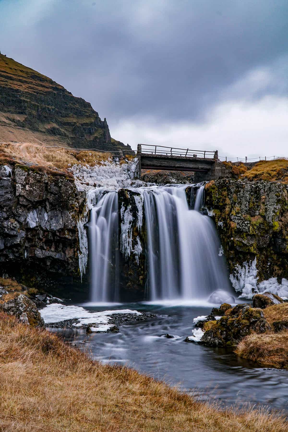
If you want the most iconic shots of Kirkjufellsfoss, I’d suggest visiting around sunset or, if you can swing it, when the Northern Lights are out, when Iceland’s natural beauty will be on full display.
There you have it—12 of our favorite waterfalls in Iceland after exploring the entire country! Do you have any questions about visiting any of these beautiful sites? Let us know in the comments below!
