
In a country that’s FULL of waterfalls, like Iceland, it’s hard to stand out for your natural beauty—but Glymur Waterfall does! In fact, towering at almost 200 meters, it was actually the tallest waterfall in the country until 2007, when another slightly taller waterfall, Morsafoss, was uncovered, due to glacial melt.
While it may have lost its impressive title, Glymur Waterfall is still absolutely worth a visit—but, in order to see this stunning waterfall and the impossibly green canyon it sits in for yourself, you’re going to have to work for it, climbing along a challenging trail to reach it. If you want to experience this beautiful spectacle for yourself, here’s everything you need to know about the Glymur Waterfall hike in Iceland.

This post may contain affiliate links. If you make a purchase through them, we may receive a small commission, for which we are extremely grateful, at no extra cost to you.
Stats for the Glymur Waterfall hike
- Length: 7.2 km (4.5 miles).
- Elevation gain: 429 meters (1,407 feet)
- Difficulty: Hard
- Trail map
It’s worth mentioning that this is typically hiked as a loop trail, which requires two crossings of the Botnsá River—the first one on a log bridge and the second one that’s directly through a shallow stream (i.e., everything below your ankles will get wet).
If you don’t want soggy feet on the return hike, you can treat it as an out-and-back trail after you reach the Glymur waterfall. This option has just a slightly shorter mileage than the loop option.
Where is the Glymur Waterfall hike?
The trailhead for the Glymur waterfall hike is located here in southwestern Iceland, about an hour and 15 minutes north of the capital city of Reykjavik, making this a great day hike from the city.

It also can be an excellent short detour on any Iceland road trip if you’re driving to some of the nearby attractions, like the Hvammsvik Hot Springs, the Snæfellsnes Peninsula, or some of the stops along a Golden Circle itinerary, like Thingvellir National Park.
How to get to the Glymur Waterfall hike
Regardless of whether you’re coming from the north or the south of Iceland, you’ll take Route 1 (i.e., the Ring Road) to Route 47, which encircles the absolutely gorgeous Hvalfjörður fjord (which translates to the Whale Fjord).
After about 45 kilometers of driving east along the beautiful coastlines of Route 47, you’ll reach a gravel road called Botnsdalsvegu, which eventually dead ends in the trailhead’s parking lot.
All of these roads are well-maintained and don’t require 4WD.

The trailhead holds about 70 or so cars. My husband, Justin, and I visited in the late morning in early September on a gloriously sunny day and found the parking lot to be about half full. However, I have heard that the parking lot can fill up during busier periods, like July and August, so if you’re visiting during that timeframe, I’d suggest trying to get here on the earlier side to make sure you can snag a spot.
When we visited in September 2025, the Glymur Waterfall hike was one of the only trails we stopped at in Iceland that didn’t have a parking fee. I know parking fees change all the time here, so let me know in the comments below if the owners of the property instill one.
There aren’t any options to take public transportation here, so you’ll generally need to have a rental car to reach the trailhead. Alternatively, there are a handful of tour options that you can take to reach the trailhead, like this private tour to Glymur.
When is the Glymur Waterfall hike open?
The Glymur Waterfall hike is only open during the warmer months, usually from late May through October.
Outside of these months, the log bridge to cross the Botnsá River along the trail is removed, given that the level of the river can become too high and the current too strong for the bridge to hold. There are no set dates for this bridge’s removal and it varies from year to year, depending on the weather.

You can technically still access the trail at this time and some people opt to forge through the river’s icy waters without the bridge. However, I really wouldn’t recommend it. The property owners remove the bridge annually for good reason—the water level can indeed be dangerously high, with swift currents, so, if you don’t want your trip in Iceland to include possible hypothermia and getting swept down the Botnsá River, there are lots of other waterfalls in Iceland to enjoy.
What to expect along the Glymur Waterfall hike
As mentioned above, the hike to Glymur Waterfall is technically a loop, which most people hike counterclockwise.
Hiking up to the Glymur Waterfall
From the parking lot, the first 1.2 km (0.9 miles) is a fairly flat pathway to the Botnsá River, with peekaboo views of rolling mountains ahead.
As you approach the river, you’ll climb down through the Þvottahellir lava cave, with an impressively tall chamber and three dramatic openings. Besides the waterfall itself, this was one of the coolest parts of the trail! Once you get your fill of pictures of the nifty cave, the trail will start curving to the left along the river.

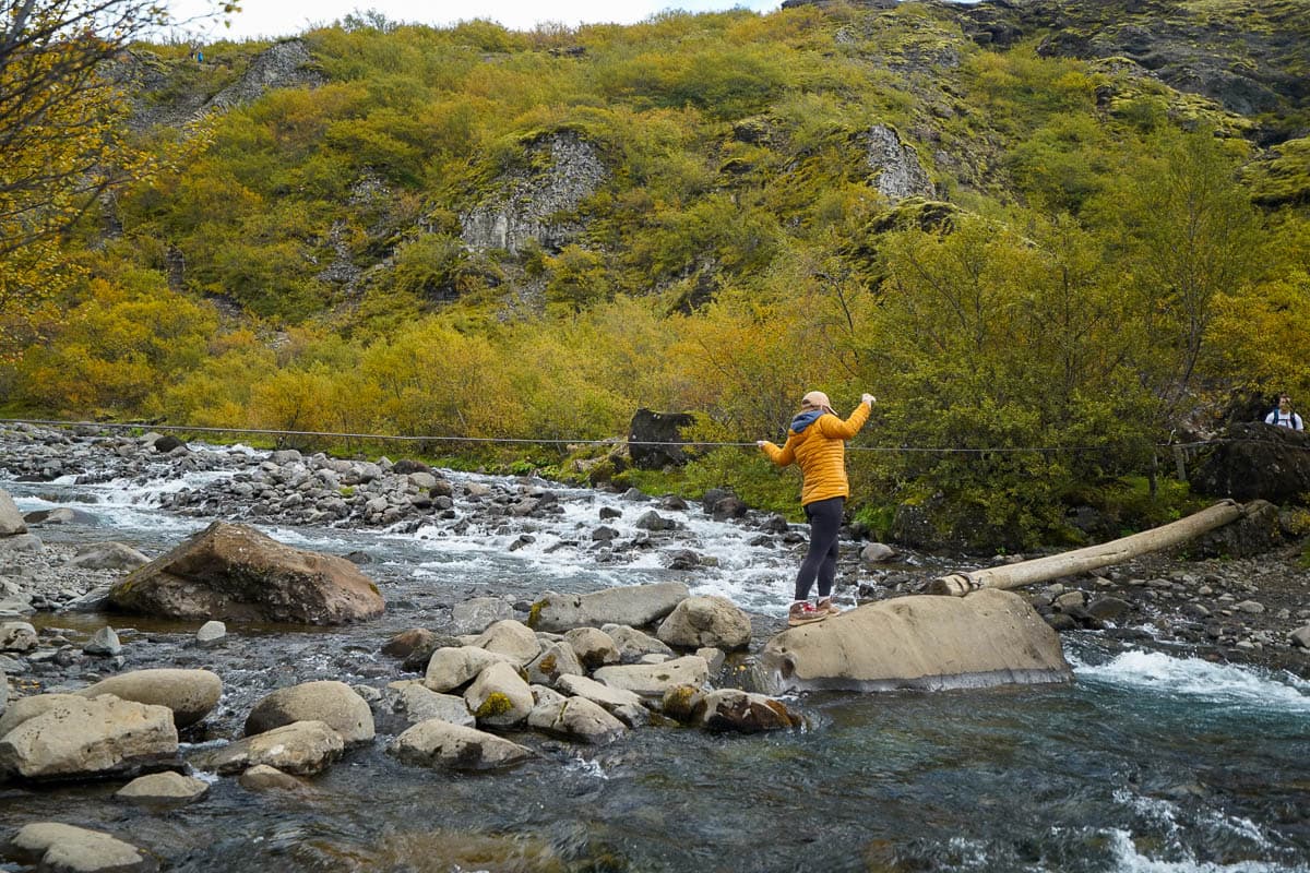
Shortly afterward, you’ll reach the first river crossing on the infamous log bridge, which has a rope tied to it that you can use for balance. I sometimes get freaked out by narrow crossings like this, but the log bridge is low enough to the ground that it doesn’t feel too intimidating—plus, the rope for balance definitely helps!
From here, it’s a one kilometer (0.6 mile) steady climb up to Glymur Waterfall. A decent amount of the way is quite steep and rocky, so be sure to wear proper hiking boots along the trail (Justin uses these hiking boots and I’ve had these boots for years and love them!). A lot of the steeper portions of the trail have a chain that you can use for extra support and to pull yourself up a bit.

There are also sections here that follow closely along a cliffside, with STEEP drop-offs, so just be sure to keep a close eye on any kiddos here.
Along the way, there are several different viewpoints of the waterfall from the trail, with a handful of informational signs about its geology and the flora and fauna found in this area. Glymur is inarguably one of the most beautiful waterfalls in Iceland, with a narrow ribbon of water careening down a towering cliffside, tucked into a deep, mossy canyon. One of my favorite aspects of this hike was watching the thousands of beautiful seabirds, called fulmars, that nest along the canyon’s rocky outcroppings and are constantly swooping overhead.
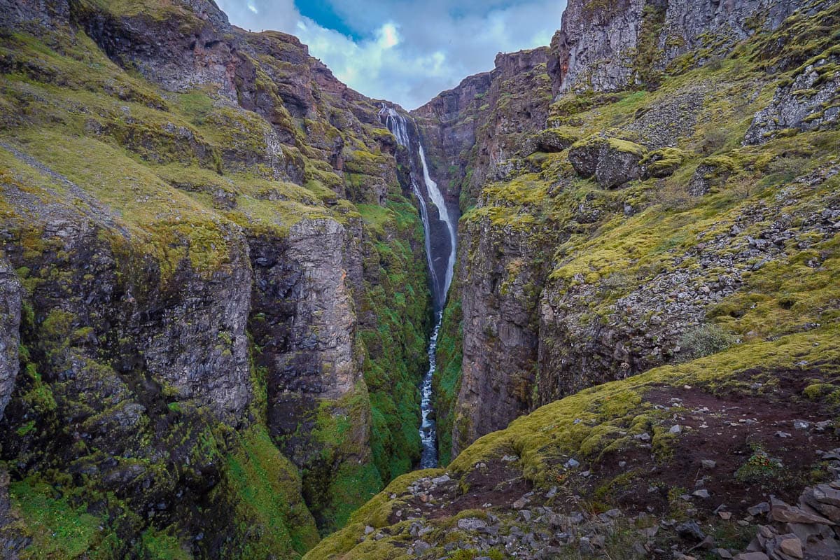
As you climb higher and higher, the view gets more and more dramatic, until you reach the final viewpoint of the waterfall, opposite of its brink.
From Glymur Waterfall back to the trailhead
From here, you can continue on the loop trail, where you’ll need to walk through a wide and shallow portion of the river, regardless of when you visit. Or, if you’d prefer not to get your feet wet, you can simply retrace your steps back to the trailhead.

Justin only brought one pair of shoes with him to Iceland, meaning, if we did the loop trail, he’d either have to get his singular pair of shoes soaking wet with icy water or hike it barefoot, which is supposed to be not the most comfortable, given the cold water and the extremely slippery, stabby rocks that are lining the floor of the river. So, ultimately, we treated this as an out and back trail (and loved it!).
If you continue on, you’ll keep hiking alongside the rim of the canyon and eventually reach a shallow area of the river, upstream of the waterfall. Here, you can cross to the west side of the canyon.
Insider tip: You can cross the river barefoot, but be prepared for your feet to be extremely cold and to get stabbed by the river rocks. So, if you want feet that remain unstabbed on this hike, it’s a good idea to bring along a second pair of shoes to wear for the water crossing.

The water is usually deep enough to go above your ankles, so I don’t think most waterproof boots will do you much good here. Instead, I’d recommend using hiking sandals, like our beloved Tevas (here’s the pair that I use and here’s the pair that Justin uses), to provide more traction and support on the slick river stones.
Once on the other side of the canyon, you’ll follow the trail along the riverside downstream. From here, you’ll get a unique and beautiful perspective of the upper portion of Glymur’s streams of water as they begin to cascade down the canyon.

After about 0.6 km (0.4 miles) downstream from the river crossing, the trail forks here. While both of the paths lead back to the trailhead and are approximately the same distance, the one to the right is the more popular option, with a gradual climb back to the parking lot along a well-trodden path. The one to the left is a more challenging trail, along steep and rocky terrain, that follows closely along the riverside.
From reading lots of other hikers’ reports, I’d generally recommend choosing the easier trail on the right. The more challenging path is not well-marked, with lots of confusing social trails, and sketchier climbs down steep cliff sides. If you opt for the more challenging option, I’d strongly recommend downloading an offline map of the Glymur Waterfall hike on AllTrails before heading here, so you can follow along, in case you get lost.
There you have it—I hope you enjoy the hike to Glymur Waterfall. It was one of our favorite trails in Iceland! Do you have any questions about this trail? Let us know in the comments below!
