
Ushuaia, located in Argentinian Patagonia, is frequently referred to as the “End of the World”—and has the otherworldly-looking scenery to boot! With epic mountains and ancient glaciers, Ushuaia is home to some of the most stunning landscapes on the entire planet, including Laguna de los Tempanos (also known as the “Vinciguerra Glacier trail”), a stunning glacial lake at the base of jagged mountains. If you want to visit this incredible place for yourself, here’s everything you need to know about hiking the Laguna de los Tempanos trail, the most incredible hike in Ushuaia.

This post may contain affiliate links. If you make a purchase through them, we may receive a small commission, for which we are extremely grateful, at no extra cost to you.
About the Laguna de los Tempanos Hike
- Length: 7.2 miles (11.6 km)
- Elevation gain: 2,165 feet (660 meters)
- Difficulty: Hard
- Trail map

How to Get to the Laguna de los Tempanos trailhead
The trailhead for Laguna de los Tempanos is located here in Ushuaia, Argentina. Ushuaia is known as the “end of the world” as it actually holds the impressive title of the southernmost city on the planet!
As you might expect, it’s not exactly the easiest place to get to. People may visit Ushuaia from nearby cities, like Punta Arenas, Chile or El Calafate, Argentina as part of their broader Patagonia itinerary. Many visitors, like my husband, Justin and I, also come to Ushuaia, due to its role as a gateway to Antarctica and other sub-Arctic destinations, like South Georgia.

Regardless of how you wind up in Ushuaia, I’m going to assume you’re staying in the downtown area. From here, you have a few ways of getting to Laguna de los Tempanos.
Self-guided
If you want to do this hike on your own, you can get a taxi (or, if your Spanish is as bad as ours, an Uber) to the trailhead. It’s located about 8 kilometers north of downtown Ushuaia along the unpaved Camino Del Valle, on the outskirts of a residential neighborhood.
It cost us 6,200 ARS (around $5.30 USD) to get an Uber from our Airbnb in downtown Ushuaia to the trailhead.
Pssst… you might not have cell service to call a taxi or Uber once you’re back at the trailhead. If so, I’d suggest getting a post-hike empanada and beer at Mak Shima Craft Beer just a few hundred yards from the trailhead. There’s free wifi for customers and it’s the perfect place to wait for your ride after a long hike.
With a tour group
If you’ve got some flexibility in your budget, one of the most adventurous things to do in Ushuaia, Argentina is to climb on the Vinciguerra Glacier. To do so, I’d strongly recommend joining a tour, so you can be with a knowledgeable guide with the necessary know-how to keep you safe on the glacier.

These tours will take care of all the logistics for you, including picking you up and dropping you off at your accommodations and preparing your lunch for you. Plus, the guides will point out wildlife, like Andean condors, wild horses, or the Andean fox that you might see along the trail, and provide the appropriate gear for glacier climbing.
If that sounds up your alley, consider:
- Group tour to Vinciguerra Glacier and Laguna de los Tempanos
- Group glacier trek to Laguna de los Tempanos
- Small group hike to Laguna de los Tempanos and Vinciguerra Glacier

In full transparency, I don’t think you need a guide if you’re just planning on hiking up to the glacial lake—the trail is generally well-marked and not particularly technically challenging. However, if you want to hike on the glacier or just prefer to learn more about Ushuaia’s unique flora and fauna, going on a hike here can be an excellent option.
What to expect along the Laguna de los Tempanos hike
From where you’re dropped off at the trailhead, you’ll walk up a dirt pathway towards a metal gate. At first, it looks like the gate is locked and has private property warning signs on it, but the smaller gate on the right hand side is open (and the warning signs are actually only applicable to vehicles, not hikers!).

Continue past this gate on the dirt path. The first mile of the hike is actually quite flat, through an open meadow and winding alongside the Arroya Grande stream. When we visited in early January, this meadow was full of beautiful yellow wildflowers that looked stunning against the mountain backdrop.
After about a mile, you’ll cross a wooden bridge over the stream and reach the tree line of a dense forest.
For the next two miles, you’ll climb up through the forest. The incline is generally pretty consistent and gradual, but there are a few incredibly steep sections, where you have to climb up slippery roots and uneven rocks. Just go slowly and watch your footing here—it would be easy to hurt yourself!

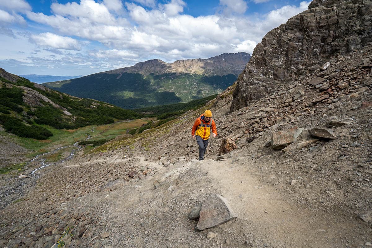
Around three miles in, you’ll pop out of the forest and onto a flat boggy moor, with epic views of the surrounding mountain peaks, like Cerros del Medio and dos Banderas, on your left hand side. After a short walk through this open field, you’ll reach the final—and most challenging—section of the hike, an extremely steep 0.3 mile climb up a scree field to the shoreline of Laguna de los Tempanos.
After you huff and puff your way to the top of this section, you’ll be rewarded with jaw-dropping views of the turquoise waters of Laguna de los Tempanos and beyond, the otherworldly looking surface of Vinciguerra Glacier.

Once you take in the views from this perspective, you can follow the shoreline around the lagoon to the righthand side right the glacier itself (and, depending on the time of year, even some ice caves!).
If you go on a guided tour, you can even climb on the cracked face of this ancient ice! I would strongly recommend against walking on the glacier if you’re not with a knowledgeable guide—there’re some really deep crevasses that you would be easy to hurt yourself (or worse!) in.
When to hike Laguna de los Tempanos
The best time to hike Laguna de los Tempanos is from December through mid-April, which is summertime in Ushuaia. We went in early January and it was absolutely perfect, with beautiful wildflowers along the trail, a pleasantly cool temperature, and a beautiful blue sky.

The trail is open year round so, theoretically, you can hike outside of this timeframe. However, given Ushuaia’s southern location (remember the whole “southernmost city on Earth” thing?), you should expect it to be quite cold and snowy along the trail, so come prepared with lots of warm layers, microspikes, and trekking poles.
Additionally, there’s sections with pretty high avalanche risk, including the steep climb up to the lake itself, so, if you’re hiking the trail during the snowier months (like June through September), be sure you’re familiar with avalanche safety and have the appropriate gear, like an avalanche beacon and probe.
Tips for the Laguna de los Tempanos hike
Download the trail map on AllTrails
As one of the very best hikes in Patagonia, Laguna de los Tempanos is generally a well-marked and easy to follow trail. Still, there are a few unmarked junctions and social trails that may easily lead you astray.
I’d strongly recommend downloading the map on AllTrails ahead of time so that you can follow along the route using GPS. You’ll need the AllTrails+ membership in order to download the offline trail map (there’s no cell service along the vast majority of the trail), but if you’re anything like us, the membership is well-worth it. We literally use the offline maps feature on a weekly basis!

Bring the appropriate gear
There’s a few things you should be sure to include on your Patagonia packing list, which will come in handy at Laguna de los Tempanos and lots of other hikes in this magical corner of the planet:
- Waterproof hiking boots: This trail is MUDDY, regardless of when you visit, so bring along waterproof boots to offer proper support and traction on the trail. Justin has used this pair for years and I love my boots.
- Trekking poles: There’s some incredibly steep parts of the trail, including the climb along the rocky scree field up to the lake and certain sections in the forest. Trekking poles will help climb up and down these super steep sections and make it less likely you’ll fall and hurt yourself (definitely not what you want to do while you’re at the End of the World!).
- Microspikes: If you encounter any snow along the trail
- Waterproof jacket and rain pants: I’d recommend checking the weather forecast before your visit—we lucked out on an absolutely BEAUTIFUL day, but I’ve heard the weather can unexpectedly turn on a dime here. It can’t hurt to pack some waterproof layers—Justin has this raincoat and these rain pants, and I have this raincoat and these rain pants.
I hope you enjoyed the Laguna de los Tempanos trail as much as we did—it’s one of our favorite hikes in Patagonia! Do you have any questions about this trail?
