
Chiricahua National Monument is one of the most uniquely beautiful hidden gems in the United States—it’s no surprise that it’s slated to become our next National Park! Between its colorful rock pinnacles with the Chiricahua Mountains as their backdrop, it looks like no place else on the planet. My husband, Justin, and I recently visited this special corner of the world and hiked almost every trail in the park—so if you want to explore the mind-blowing landscape for yourself, here are the 6 best hikes in Chiricahua National Monument.

This post may contain affiliate links. If you make a purchase through them, we may receive a small commission, for which we are extremely grateful, at no extra cost to you.
What is Chiricahua National Monument?
Chiricahua National Monument, located in southeastern Arizona, contains the remnants of an ancient eruption of the nearby Turkey Creek Volcano, which spewed a massive amount of ash and pumice into the air. Once it fell to the ground, it hardened and, over the millenia, this rock layer has eroded into countless spires, hoodoos, and formations, which the Apaches once called the “standing-up rocks”. Beyond its volcanic rock formations, Chiricahua is considered a “sky island”, basically an isolated mountain range that juts out of the surrounding desert.

Because of its unique geological makeup, Chircahua has been called a “Wonderland of Rocks” and was made a National Monument in 1924. There’s also been a congressional push since 2021 to make Chiricahua the newest addition to become an official U.S. National Park.
Best Hikes in Chiricahua National Monument
Before we dive in, it’s worth pointing out that many hikes in Chiricahua, especially loop trails, are comprised of multiple shorter trails, which all have different names. The park is well-signed, but doing one of these longer hikes can still be a bit confusing, given that they can include five or more differently named trails.
Accordingly, I’d strongly recommend downloading the trail map on AllTrails ahead of time (I’ve linked to all of the trails below), so you can follow along with your route on GPS and can reference the names of the trails that are included on your larger hike.

You’ll need AllTrails+, a premium membership, to download offline maps (there is no cell service anywhere near Chiricahua), but, as a frequent hiker myself, it’s well worth the cost—it’s probably in my top five most used apps!
Easy Hikes
1. Massai Point Overlook
- Length: 0.4 miles
- Elevation gain: 52 feet
- Difficulty: Easy
- Trail map
To reach this trail, you’ll drive all the way down Bonita Canyon Drive, which, given that the road is lined with towering rock spires, is one of the most scenic drives in the United States.

At the road’s end, you’ll find this nature trail, which leads to Massai Point, one of the most jaw-dropping overlooks in the park, with stunning views of the Chiricahua Mountains in the distance. There are plenty of educational signs about the park’s geology and history along the way.
This is an excellent option for beginner hikers, and a significant portion of the trail is wheelchair accessible.
Moderate Hikes
2. Echo Canyon Loop
- Length: 3.2 miles
- Elevation gain: 557 feet
- Difficulty: Moderate
- Trail map
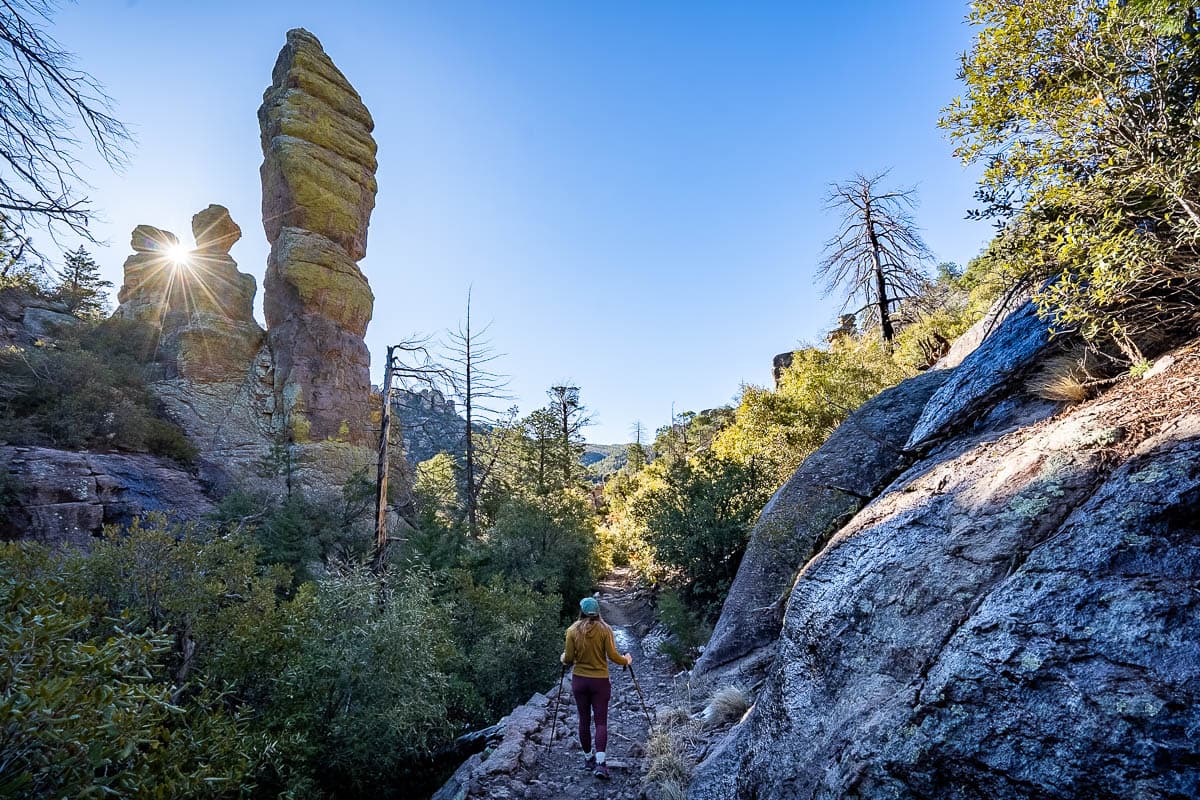
Echo Canyon is probably the most popular trail in Chiricahua—and for good reason! The trail leads down a series of steep switchbacks, which weave directly in between towering rock pinnacles and hoodoos. It’s one of the best trails to truly immerse yourself into the park’s unique landscape.

About 0.5 miles from the trailhead, keep your eyes peeled for a sign that says “Grottoes” on your righthand side (it’s super easy to miss—we totally did the first time around!). Here, the enormous boulders have eroded away to form a tunnel-like hallway of sorts that you’re free to climb around and explore—they feel kind of like a hidden cave!
Some people hike Echo Canyon as an out-and-back trail (which would be approximately 3 miles long) or, instead, decide to make this a loop trail, by turning left on the Hailstone Trail and climbing back up to the parking lot along the Ed Riggs Trail. If you do the full loop, I’d recommend hiking the trail counterclockwise, hiking down the Echo Canyon Trail and up the Ed Riggs Trail, instead of vice versa—it’s WAY less steep that way!
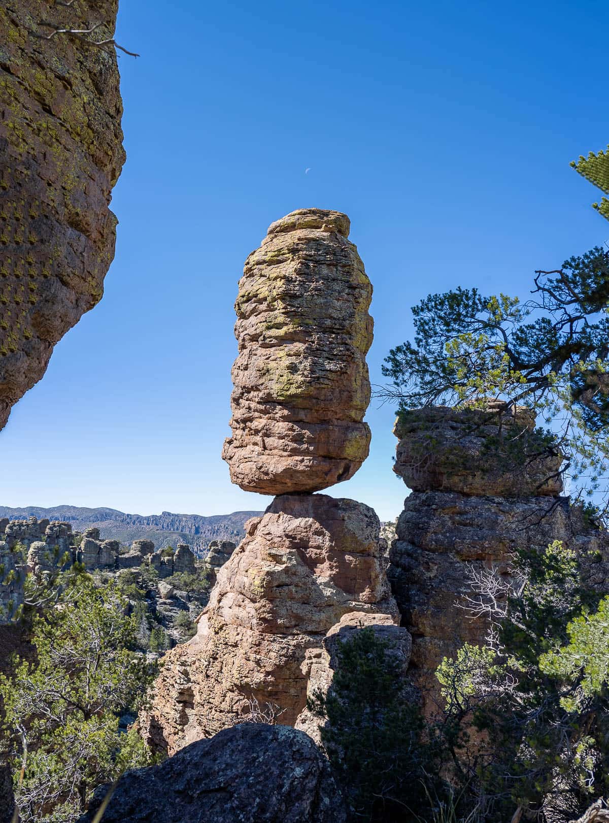
3. Heart of Rocks Loop
- Length: 7.3 miles
- Elevation gain: 1,591 feet
- Difficulty: Moderate
- There are actually two popular options to hike this trail, so I linked the two maps below.
The Heart of Rocks Loop is more rugged than a lot of other trails in the park, with lots of rock steps, sections that require scrambling, and an unclear pathway in certain areas. Still, your effort is totally worth it—this section of the park is home to some of its most iconic rock formations, like the aptly named Big Balanced Rock and Old Maid—plus, in my opinion, the technical challenges make this trail fun!

Heart of Rocks Loop is actually only a mile long, but its trailhead is actually located smackdab in the middle of all of the hoodoos and rock spires—meaning you’ll actually need to hike along other trails to reach the loop first.
There are countless trail combinations that you could take to get to Heart of Rocks, but there are two popular options, both of which are 7.3 miles long.
Echo Canyon trailhead to Heart of Rock Loop
With this option, you’ll hike the Ed Riggs, Mushroom Rock, and Big Balanced Rock trails, to finally reach the Heart of Rocks loop.
This is what we did and LOVED it—the trail is incredibly diverse, ranging from dense pine tree forests and towering canyons to jawdropping mountain vistas and, of course, lots of impressive rock formations. Highly recommend!

Visitor Center to Heart of Rocks Loop
With this option, you’ll start your hike at the Visitor Center, climbing up the Lower Rhyolite Canyon and Sarah Deming trails to reach Heart of Rocks.
This is the more challenging option of the two, thanks to the Sarah Deming portion of the hike, which comes with lots of stairs and even some scrambling here or there.
4. Inspiration Point Trail
- Length: 7.3 miles
- Elevation gain: 1,591 feet
- Difficulty: Moderate
- Trail map
This trail leads you to one of the best viewpoints in the park, Inspiration Point, which provides a panoramic view of basically the entire National Monument, with all of its countless spires and hoodoos, and, off in the distance, the snow-capped peaks of the Chircahua Mountains.

To get to this overlook, you’ll start from the Echo Canyon trailhead (or, if that parking lot is full, you can alternatively start at Masai Point) and hike down the Ed Riggs and Mushroom Rock trails, which will ultimately connect you to Inspiration Point.
The trails that lead to the viewpoint are primarily through a canyon followed by a conifer forest, so you don’t really get a ton of opportunity to see the park’s unique rock structures up close on this hike. That being said, Inspiration Point was my personal favorite overlook in all of Chiricahua and offers the best sunset views in the park—so it’s still worth doing, in my opinion!
5. Sugarloaf Mountain Trail
- Length: 1.9 miles
- Elevation gain: 498 feet
- Difficulty: Moderate
- Trail map
This trail is located away from Rhyolite, Echo, and Bonita Canyons, where most of the trails, hoodoos, and rock spires are concentrated. Still, Sugarloaf Mountain has an impressive claim to fame—at 7,310 feet above sea level, Sugarloaf Mountain is the tallest point in the park!

Accordingly, after a gradual and consistent climb to the summit, it provides arguably the best view in the park, with views of the surrounding rock pinnacles, mountains, and valleys in every direction. Plus, there’s some other cool features on this trail, including a tunnel blasted into the volcanic rock and a fire lookout, both constructed by the Civilian Conservation Corps in the 1930s (any other CCC fans out there?!).
6. Lower Rhyolite Canyon
- Length: 3.6 miles
- Elevation gain: 754 feet
- Difficulty: Moderate
- Trail map
This trail offers different views as compared to a lot of the other trails, which climbs along the southern wall of Rhyolite Canyon.
Initially, the trail is quite shaded (which may be much appreciated on a hot day), but eventually opens up to provide views of the north canyon wall, which is littered with pinnacles and spires.

Again, I wouldn’t say this is my absolute favorite hike in the park. However, this hike is on the easier side of moderate, so it would be a good option if you’re short on time or are a beginner hiker that’s ready to tackle something a bit more challenging. Plus, it’s supposed to be an excellent spot for birding, with species like broad-tailed hummingbirds, Arizona woodpecker (February-November), and Grace’s Warbler regularly being spotted along the trail.
7. Natural Bridge Trail
- Length: 4.7 miles
- Elevation gain: 1,040 feet
- Difficulty: Moderate
- Trail map
If you’re up for something slightly more challenging, consider this trail.
From the trailhead, the pathway leads up to a small plateau that provides nice views of the surrounding rock formations and then climbs downhill into a dense conifer forest.
Most of the trail weaves through the forest, but it opens up near the trail’s endpoint, where you’ll see a rhyolite natural arch about 400 feet away.
While the arch itself is actually quite large, it’s hard to distinguish it from the cliff that’s directly behind it, especially in the morning, when it sits in a massive shadow. Accordingly, I’d recommend heading here in the afternoon, when the arch is properly lit up and looks much more impressive.
In full transparency, this definitely isn’t my favorite hike in Chiricahua. The trail is on the northern side of the park and the rock pinnacles aren’t as dense or impressive in this section. However, because the trail is in a more isolated section of the park, it also tends to be one of the least visited trails here. Accordingly, it’s a great option for escaping the crowds if you happen to be visiting during a busier period.
Challenging Hikes
8. The Big Loop
- Length: 8.0 miles
- Distance: 1791 feet
- Difficulty: Challenging
- Trail map
If you want as much bang for your buck as possible, I’d strongly recommend hiking the Big Loop Trail, which, true to its name, combines all of the best trails and sights in the park into one massive loop. If you want the full breakdown of the hike, the loop is comprised of the following trails, if you go clockwise: Echo Canyon, Upper Rhyolite Canyon, Sarah Deming, Heart of Rocks Loop, Big Balanced Rock, Inspiration Point, Mushroom Rock, and Ed Riggs trails.
Along the way, you’ll pass a sampler platter of everything Chiricahua has to offer—towering canyons, dense pine tree forests, mountain views, and all kinds of cool rock formations.
It’s common wisdom that the best way to hike this loop is counterclockwise (starting in Echo Canyon and ending along the Ed Riggs trail), given the climb back up to the parking lot is much more gradual.
However, we actually hiked the trail clockwise and, while the last segment of the hike was pretty steep, it also meant we ended our hike with one of the most spectacular sections of the park, Echo Canyon. It kind of felt like the grand finale of Chircahua—the epic views of the surrounding rock formations definitely were a good distraction from our burning thighs!
Tips for hiking in Chiricahua National Monument
Bring sun protection
While some of the trails pop in and out of conifer forests, the vast majority of the trails are exposed to the sun, which can, unsurprisingly, get pretty intense in southeastern Arizona. So be sure to bring along sun protection, including a hat, sunglasses, and sunscreen, and plenty of water (we swear by these comically giant Nalgene bottles).

Be prepared for ice and snow
While you may expect southeastern Arizona to be toasty warm year round, Chiricahua is actually at a pretty high elevation—-up to 7,310 feet above sea level. Accordingly, there can be ice or snow for a significant chunk of the year, from around October through November.

We actually camped in our RV on neighboring National Forest land to Chiricahua during our visit in March and just assumed that the springtime weather wouldn’t impact our camping at all. But it snowed quite a bit during our visit and dropped well below freezing—things that typically aren’t so great for RVers.
So, with that in mind, I’d suggest bringing crampons along if you’re visiting from the late fall through the springtime, in case you encounter any ice or snow along the trail, to provide extra support and traction.
How to Get to Chiricahua National Monument
Chiricahua National Monument is pretty remote, with the quirky mining town of Bisbee being its closest decently sized town (about an hour and 20 minutes away) and Tucson being the closest large city with an airport (about two hours and 10 minutes away).
Accordingly, if you’re traveling from afar to explore Chiricahua, your best bet will be to fly into Tucson International Airport.

Tucson is a surprisingly cool city, with a killer food and beer scene—plus, it’s one of the only proper U.S. cities with its own national park, Saguaro, which protects over two million of the United States’ largest cactuses. And if you love hitting the trail, there’s some seriously awesome hikes in Saguaro National Park!
Where to Stay While Visiting Chiricahua National Monument
Given Chiricahua’s remoteness, I’d suggest staying in the nearby old mining town of Bisbee, which offers the perfect mix of historical charm with artsy quirkiness.

Consider staying at:
- Letson Loft Hotel: This boutique hotel is conveniently located in the heart of Bisbee and offers all the modern amenities you could ever want while preserving the property’s historical bones. There’s thoughtful perks, like cozy robes and a complimentary continental breakfast.
- Canyon Rose Suites: This centrally located hotel offers HUGE rooms, with a well-equipped kitchen and seating area, plus nice touches, like free local snack and drinks and bike rentals.
- Inn History Tombstone: This newly updated hotel has the MOST comfy beds, in-room tea and coffee-makers, and free private parking (which is actually hard to come by in Bisbee!).
We loved exploring all of the hikes in Chiricahua and hope you do as well! Do you have any questions about these trails? Let us know in the comments below!
