
Quebec is one of the most stunning Canadian provinces, with dramatic glacier-carved valleys and towering granite formations. One of the most epic trails to enjoy Quebec’s otherworldly beauty is the Mont du Dôme hike, located in Zec Des Martres in the Charlevoix region of Quebec. The trail offers jaw-dropping views of the surrounding valley and the titular mountain, which stands almost 1,000 meters tall.
If you want to explore this beautiful corner of Canada for yourself, here’s everything you need to know about Mont du Dôme, from what to expect along the trail to the best season to visit.
This post may contain affiliate links. If you make a purchase through them, we may receive a small commission, for which we are extremely grateful, at no extra cost to you.
About Mont du Dôme
Here are some quick stats about Mont du Dôme:
- Length: 9.3 km (5.8 miles)
- Elevation gain: 542.8 meters (1,781 feet)
- Difficulty: Challenging
- Trail map
How to get to the Mont du Dôme Trailhead
The Mont du Dôme trailhead is located here, in Zec Des Martres, which is a protected wilderness area that’s located about an hour and 35 minutes north of Quebec City. The best way to get here is via car, as there isn’t a way to take public transportation here.
The trailhead parking lot is pretty small, only holding about 20 or so cars. We hiked the trail on a weekday in late September and basically had the whole thing to ourselves. However, if you’re visiting on a weekend during summer or fall when it’s a lot busier, I’d definitely recommend getting here on the early side to snag a spot.
To park here, you need to fill out a registration form, with some information like your license plate and when you started your hike, and leave it on your dashboard. No pens are provided, so be sure to bring one with you!

There’s also a voluntary $7 donation, which you can pay via a QR code. My husband, Justin’s and my cell service didn’t work here, so, if you have the same issue, I’d suggest taking a photo of the QR code and making your donation once you’ve returned from your hike.
Insider tip: The trail is a bit confusing, with several offshoots and social pathways along the way. Given that our cell service didn’t work here, I’d strongly suggest downloading a trail map on AllTrails+ ahead of time to follow along.
What to expect along Mont du Dôme
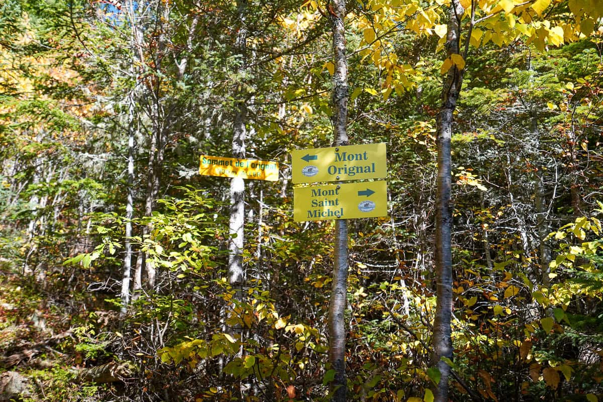
The Mont du Dôme hike is actually pretty unique. It’s a loop trail, with different spokes deviating from the main pathway, leading up to three mountain summits along the way—Mont St. Michel, Mont de l’Original, and, of course, Mont du Dôme.
Which direction should you hike the Mont du Dôme loop?
If you hike the trail clockwise, you’ll hit Mont du Dôme first. To reach this summit, you’ll need to scramble up a 0.6 km long steep section, over a series of large and uneven boulders.

If you hike the trail counterclockwise, you’ll hit Mont St. Michel first, along a slightly more gradual and less technical uphill climb.
Justin and I decided to do the trail counter-clockwise, because the uphill portion was less steep and we wanted to save Mont du Dôme for the end. To be honest, though, I don’t really know that I have a super strong recommendation one way or the other.
Mont St. Michel and Mont du Dôme have equally stunning views, in my opinion. Plus, while going up the steep scrambling section to Mont du Dôme is more of an intense cardio and keg workout, it can be MUCH easier to hurt yourself if you’re, instead, heading downhill on this portion of the trail.

From checking the AllTrails reviews, it seems like most hikers do the trail clockwise to avoid going downhill on the scrambling part, so I’m covering hiking the trail this way.
From the trailhead to Mont du Dôme
From the trailhead, you’ll walk through a forested pathway with a very gradual incline for 0.3 km, until you reach the fork where you need to decide whether to go clockwise or counterclockwise. So here, you’ll need to make a left on the trail to head up to Mont du Dôme.
The incline becomes a bit more intense here for about 0.2 km, before you run into the aforementioned STEEP section that requires scrambling over pretty large boulders. Just be sure to go slowly here, especially if there’s any precipitation or fallen leaves on the rocks—they can get REALLY slippery.

Eventually, the pathway transitions back to a packed dirt trail. Around 1.4 km into the trail, there will be another fork off to the left that heads up to the summit of Mont du Dôme. The start of this pathway is REALLY steep, with a series of shallow stairs carved into the hillside, but the incline mellows out and becomes a bit less gradual the rest of the way up to the summit of Mont du Dôme.
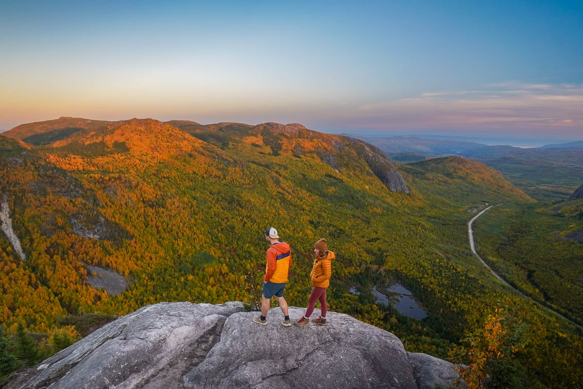
About 2.5 km into the trail, you’ll finally pop out of the forest and, for the first time along the trail, you’ll get stunning views from a rocky outcropping over Parc national des Grands-Jardin to the west.

From here, the trail continues for another 0.1 km through some dense shrubbery and up a series of granite steps, where you’ll reach the summit of Mont du Dôme. This point provides pretty vistas over Zec Des Martres to the north, but the real stunner is definitely the first viewpoint you come across!
Mont du Dôme to Mont de l’Original
From the summit of Mont du Dôme, you can turn around and retrace your footsteps back to the trailhead or, if you want to complete the full loop, continue on clockwise once you return to the main pathway.
Almost immediately after turning left onto the main trail, you’ll pass the shores of Lac du Gros Rosseau. There are some openings in the forest, where you can walk up to the rocky shoreline and admire the lake and the surrounding hills, covered with pine trees.

Continuing on, the forested pathway remains fairly flat until you reach another fork about 4.8 km into the trail. This is the offshoot you’ll need to turn on to hike up to both Mont de l’Original and Mont St. Michel.
Once you turn left onto this offshoot, you’ll hike about 0.3 kilometers along a flat pathway until you reach a fork—to the left is the summit of Mont de l’Original and to the right is the summit of Mont St. Michel.
The ascent up to Mont de l’Original, which is actually the tallest point on the whole trail, is short (at just another 0.3 kilometers), but pretty steep. Towards the end of this section, you’ll again pop out of the forest and have pretty views of the surrounding granite mountains and the rolling hillsides, covered with pine and birch trees.
Mont de l’Original to Mont St. Michel
From the summit of Mont de l’Original, retrace your steps 0.3 km back to where the trail branches off to the top of Mont St. Michel.

The 0.5 kilometer climb up to Mont St. Michel was one of my favorite sections of the trail—it’s much more open than the rest of the heavily forested trail, allowing you gorgeous views of the surrounding rolling hills.
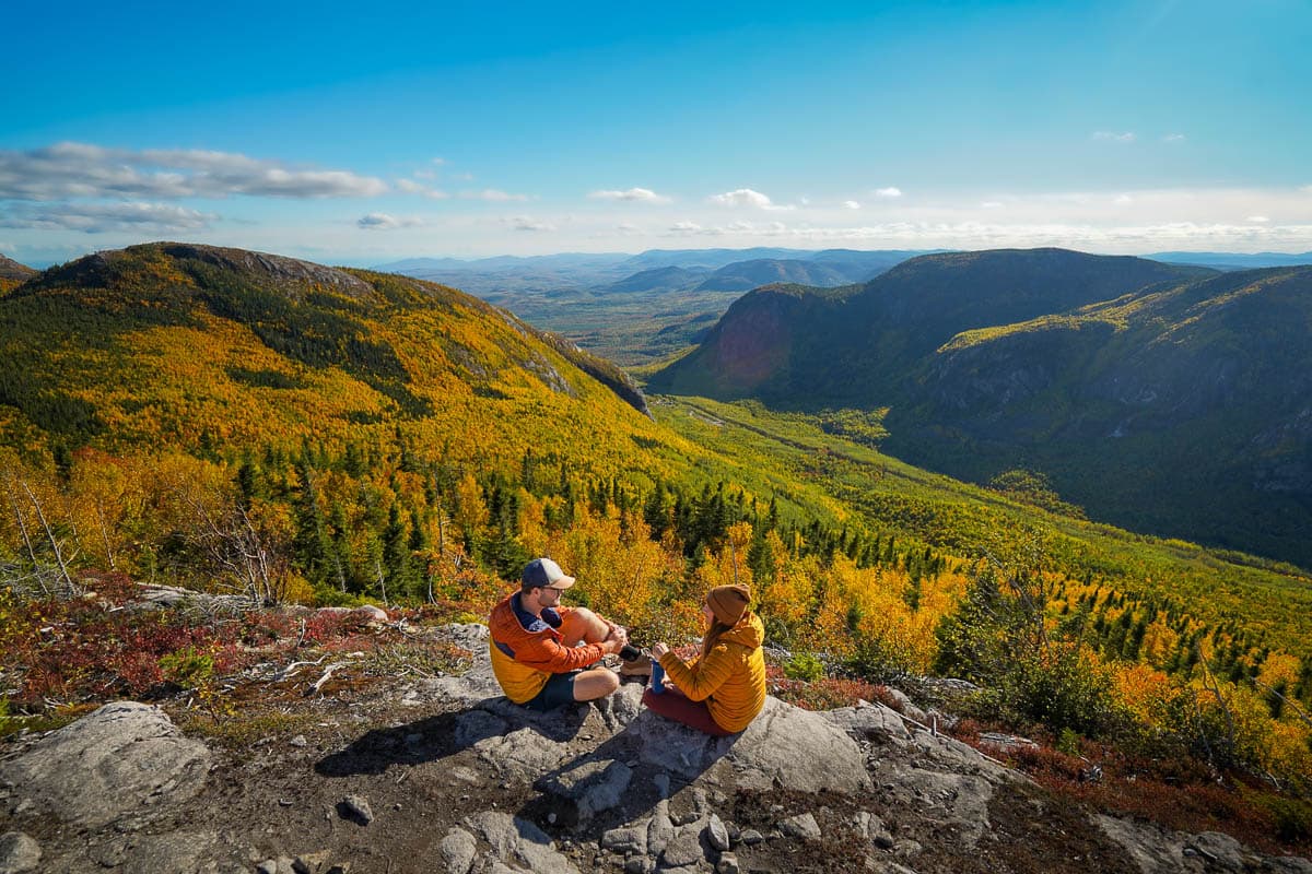
Plus, the views at the top of Mont St. Michel are arguably just as beautiful as from Mont du Dôme—you actually get to see the titular mountain off to the west and have sweeping views of the surrounding valley and Parc national des Grands-Jardin to the south.
This is a great place to have lunch or just enjoy a breather.
Mont St. Michel to the trailhead
From the summit of Mont St. Michel, head back downhill to the main pathway, which heads along a series of long switchbacks, with a gradual downhill slope, through the forest.

About 8.8 kilometers into the trail, you’ll complete the loop section of the trail and have a short, flat hike back to the trailhead.
When to hike Mont du Dôme
From around May through October, the trail is usually clear of snow and ice, making it a bit less sketchy to complete.
To see Mont du Dôme at its most beautiful, I’d highly recommend visiting in the fall, when the forest along the trail and the surrounding valley is aflame with spectacular autumnal colors. We visited during the last week of September and the trees were just a bit before their peak fall foliage—I bet, if we had visited just a week later, the views would have been even MORE spectacular.

The timing of peak fall colors here varies from year to year, but late September through very early October is a good time to aim for. Quebec publishes this fall foliage map and regularly updates it, starting every September, so that you can track how the colors are looking across the province.
As an added bonus, there are tons of epic fall hikes in the Charlevoix region of Quebec, like the Acropole des Draveurs hike in Hautes‑Gorges-de-la-Rivière‑Malbaie National Park and L’Eperon Trail in Jacques Cartier National Park.
The trail is open year-round, but from April through March, you’re likely to encounter snow and ice on the trail. If you just want to hike to Mont du Dôme, you can get by with bringing along microspikes, but if you want to try to tackle the other two summits, your best bet would be to pack some snowshoes to help get along the flatter section with deep snow. Here’s the pair of snowshoes that Justin uses and here’s the pair that I use.
Tips for hiking Mont du Dôme
Consider hiking the trail at sunrise and sunset
The views along Mont du Dôme are absolutely gorgeous, but they’re even MORE stunning at sunrise and sunset.
We hiked the trail so that we finished at Mont du Dôme at sunset and it was BREATHTAKING, with the soft glowy light of the setting sun making the fall foliage look that much more vibrant. There were some dramatic shadows here, though, so I’d also love to see what the views are like at Mont St. Michel for sunset!

If you hike at either sunrise or sunset, just remember that you NEED to have a headlamp to stay safe on the trail in the dark. We passed several people who were hiking after the sunset without a headlamp or even a cell phone to light their way, which seems straight up dangerous!
You can use a drone
If you want really epic photos and videos here, you can use a drone, like the one that we have, as the trail is in Zec Des Martres and not a national park.
However, be mindful not to disturb other hikers on the trail and be sure to not stray into the nearby Parc national des Grands-Jardin. Drones are strictly prohibited in all Canadian national parks and flying there illegally can result in a fine of up to $25,000!
Use trekking poles
Some of the grades along the trail are pretty intense, being as steep as 45%!

Accordingly, I’d suggest bringing along trekking poles to help provide extra stability and balance on some of the trickier parts of the trail.
We were BLOWN away by the Mont du Dôme hike—we truly didn’t know that Quebec was this beautiful! Do you have any questions about this trail? Let us know in the comments below!
